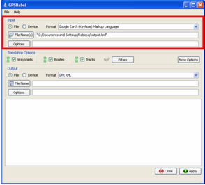
Loading Turgalicia points of interest in GPSBabel

1. About GPSBabel

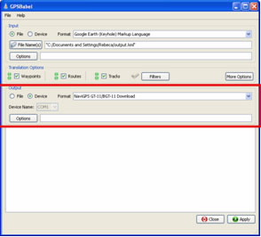
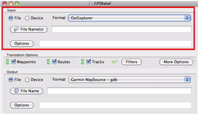
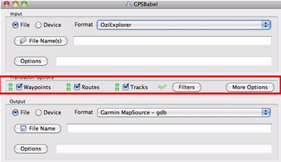
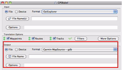
The GPSBabel program allows for the conversion of more than 140 file formats so you can work with them in different programs for editing and processing geographical information and different GPS receiver models.
There are versions for Linux, Solaris, OpenServer, FreeBBs, Windows 95, 98, ME, 2000, XP, OSX and UnixWare systems.
Downloading GPSBabel according to operating system is as follows:

  1. For Windows: You can download GPSBabel for Windows, from the website: http://www.gpsbabel.org/download.html
    The file name is GPSBabel 1.4.1. Setup.exe. Once downloaded, proceed with the installation on the computer.

  • For Linux: To obtain a free and open version of GPSBabel for Linux, go to: http://www.gpsbabel.org/download.html
    With the name GPSBabel-1.4.1.tar.gz

  • For Mac/OS: To obtain a free and open version of GPSBabel for Mac, you can download from: http://www.gpsbabel.org/download.html
    Its name is GPSBabel-1.4.1.dmg
    By doing so, you download the .dmg file which should be included in the hardware applications.

  • You can download a Windows version at the website: http://www.nauticaygps.com.ar/GPS/gpsbabel/descargas/actualiza_contador.php?archivo=gpsbabel-1.3.6.zip&path=cont_desc.dat
    The executable program is very easy to use, it will download as a file that must be decompressed. Once decompressed, select the executable program GPSBabelGUI and save it on the computer.
    The GPS models and formats compatible with the GPSBabel program include multiple brands and a wide variety of models.

    2. GPSBabel for Windows operating systems

    The installation of points of interest is identical for “GPSBabel for Windows” and for “GPSBabel executable”.

    2.1. Loading points of interest

    Once the program is installed, by following the steps in the corresponding dialogue boxes, the user can then execute it from the shortcut created on the desktop.
    Once the files have been downloaded, they can be entered into the program in the input section, giving them, first, the format file format. For example, if it is a KML, the format would be Google Earth (Keyhole) Markup Language.
    In the File Name tab look for the saved file, and in the options tab you can select different types and/or leave the default.

    GPSBabel

    2.2. Transformation options

    Once the files are incorporated, you must select the Translation Options preferred by the user, this will choose the geometry of the object, points, routes or tracks. The default options can be maintained.

    GPSBabel

    2.3. POI Outputs

    Once the file is entered and the transformation options are selected, you can export the file to another format or install it directly onto the GPS.

    1. Selecting a new format: If you want to convert the file to another format you should choose this, in the Output option and in the format tab.In the file name option you must choose the directory and name with which the new file will be saved.

    GPSBabel

    The last step is accepting the procedure by selecting the apply option.
    The result will appear in the GPSBabel program screen, confirming that the transformation was carried out successfully.

    GPSBabel
  • Incorporating the files onto the GPS. If you have a Garmin, Magellan, DeLorme PN-20, PN-30 or PN-40 or a NaviGPS GT-11 or BGT-11 GPS you can carry out the incorporation directly from GPSBabel onto the device.

  • To do so, in the Output option, choose the Device option and select the GPS model.

    GPSBabel

    In order to incorporate the file onto the GPS, you must click on apply; the completed process will appear on the blank screen.

    3. GPSBabel for Linux

    3.1 Loading points of interest

    First, connect the GPS to the computer.
    Open the command interpreter console and execute the following:
    Gpsbabel –i (file format) –f (file name with extension) –o (GPS) –F (serial port where the GPS is connected)
    Example:
    GPSBabel GPSBabel
    This will load the files onto the GPS.

    4. GPSBabel for Mac OS/X

    4.1. Loading points of interest

    Once the files are downloaded, they are loaded onto the device's program in the input section, first assigning a file format.
    In the File Name tab, look for the file. For example OziExplorer, and in the options tab you can change these, although usually the default is left.

    GPSBabel

    4.2. Transformation options

    Once the files are incorporated, you must select the Translation Options, along with the object geometry, points, routes or tracks.

    GPSBabel

    4.3. POI Outputs

    Once the file is incorporated and the transformation options selected, you can perform the conversion and load directly onto the GPS.

    1. Selecting the new format: To choose a new format from the Output options, in the format tab and in the file name option, you must select the directory and the new name to be saved.

    GPSBabel

    With apply the changes are accepted and the options set.
    The result will appear in the GPSBabel program screen, confirming that the transformation was carried out successfully.

  • Incorporating the file onto the GPS: If you have a Garmin, Magellan, DeLorme PN-20, PN-30 or PN-40 or a NaviGPS GT-11 or BGT-11 GPS you can carry out the incorporation directly from GPSBabel.

  • Arriba
    Help us improve!